
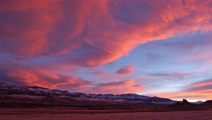
The sun sets over Carter Mountain with Castle Rock visible on the right in the South Fork Valley near Cody, Wyo. (Ruffin Prevost/Yellowstone Gate – click to enlarge)
By Ruffin Prevost
The road between Cody, Wyo. and Yellowstone National Park is often called “the most scenic 52 miles in America.” But for a spectacular drive that locals cherish and most visitors never discover, take a trip through the South Fork Valley.
Wyoming Highway 291, also known as the South Fork Road, meanders for more than 40 miles along the South Fork of the Shoshone River. It stretches from Yellowstone Avenue in Cody to the end of a remote and scenic valley that is rich in history and home to an extraordinary diversity of wildlife.
Before their confluence at the Buffalo Bill Reservoir where they emerge as the unified Shoshone River, the North Fork and South Fork of the Shoshone track separate paths, each with adjacent highways following along wide valley bottoms.
The North Fork route is busy all summer with RVs, buses and other vehicles going to and from Yellowstone. But the South Fork Road doesn’t connect to any other major route. It ends at the foot of rugged mountains that mark the start of a trail leading to the Thorofare, some of the most remote backcountry in America.
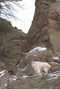
A mountain goat keeps a watchful eye from a high perch along the Upper South Fork of the Shoshone River near Cody, Wyo.
Traveled mainly by ranchers, farmers and other local residents, the South Fork Road is never clogged with tourist traffic, although you may have to slow down for cattle drives or hay trucks.
“It’s one of my favorite drives,” said Bob Richard, a Cody tour guide who leads sightseeing and wildlife watching trips along the South Fork Road. “It’s a great drive if you’re interested in seeing wildlife.”
Aside from bison and caribou, every wild ungulate species found in the Northern Rockies can be spotted along the South Fork, including moose, pronghorn antelope, elk, mule deer, white-tailed deer, mountain goats and bighorn sheep. And with all that big game wandering around, predators are always nearby, including grizzly bears, black bears, wolves, coyotes, foxes, along with raptors like hawks and eagles.
Abundant game is one reason why the South Fork area was populated for centuries by indigenous people before the arrival of white settlers.
One early rancher with a major South Fork presence was Judge William Carter, for whom Carter Mountain is named, according to a local history written by Lucille Patrick. Carter first brought cattle to the South Fork in 1879.
Carter Mountain, on the left as you drive upstream along the valley leaving Cody, is actually multiple peaks stretching across 30 miles, and is the largest mountain mass in the greater Yellowstone area. For a scenic side-trip along a dirt road into the Shoshone National Forest on Carter Mountain, look for the Carter Mountain Access Road about 18.5 miles from Cody.
William F. “Buffalo Bill” Cody recruited German immigrants to settle the lower South Fork Valley, in the Diamond Basin area, on the left about five miles after leaving Cody.
“Bill Cody brought them out here from Ellis Island. He paid their rail fare and gave them a wheelbarrow, a hoe, an axe and a shovel,” Richard said. Cody wanted ranchers and farmers to move to the area in the early 1900s to help establish the new town of Cody, and to work on a massive irrigation project the showman backed as an investor.
The overly ambitious irrigation scheme went bankrupt, with many of its ditches and canals being incorporated into today’s Cody Canal, Richard said. But the area remains a center of agriculture populated by descendants of those German immigrants and others.
About halfway up the valley stands Castle Rock, a prominent column of volcanic rock that stands alone, jutting dramatically from the valley floor. Castle Rock serves as a visual divider today between the lower South Fork Valley and the more remote upper South Fork Valley, which is home to historic ranches and many exclusive, private recreation properties.
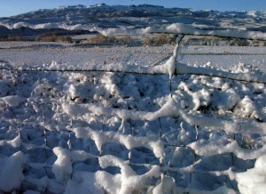
Snow collects on a fence near Sheep Mountain in the South Fork Valley near Yellowstone National Park. (Ruffin Prevost/Yellowstone Gate)
In his journal from 1873 documenting a trip through the area, Capt. William Jones of the U.S. Army Corps of Engineers, wrote that local Indians knew Castle Rock as Ishawooa, which means “rock in the valley,” and they referred to the South Fork River as the Ishawooa River, named after the rock. A creek near the far southern end of the valley is known today as Ishawooa Creek.
Above Ishawooa Creek is a seasonally recurring, natural optical illusion. The image of a horse’s head can be seen each spring, formed by snow as it clings to the face of Ishawooa Mesa. Reins formed by the snow will “break” as the weather warms, giving outfitters a good idea that enough snow has melted to allow them to travel into the Thorofare backcountry.
About 35 miles from Cody is the TE Ranch, first established by Buffalo Bill Cody as a horse and cattle ranch and also used by the famous showman to entertain visiting guests and as a hunting property.
“I love the view from the TE hills,” said Meg Sommers, a Cody nature and wildlife photographer who also works as a tour guide. “That whole area has a big, open, expansive feel, and I like the way the road follows the river.”
Just a few miles past the TE Ranch is the Valley School, a remote, one-room schoolhouse still in use by local children. The playground has a high fence to keep grizzly bears out, and the school is a popular summer fishing spot.
Near the school, the Valley Ranch is known as the cradle of the dude ranch industry. Larry Larom, a wealthy New Yorker, visited Cody after seeing Buffalo Bill’s Wild West show at Madison Square Garden. In 1915, he partnered with Winthrop Brooks, scion of the Brooks Brothers clothing family, to buy Valley Ranch and run it as a guest ranch where wealthy East Coast families vacationed for weeks at a time. It later operated as a school for boys before closing during the depression.
Beyond Valley Ranch is the Deer Creek Campground, which includes a shady picnic area just before the end of the road at Cabin Creek.
“Deer Creek is always a nice spot to stop and have lunch before turning around and heading back,” Sommers said. “There is also lots of great hiking and horse trails there.”
While the earliest visitors to the South Fork Valley went by foot or on horseback, it’s an easy half-day trip by car. Gas up first and pack a lunch, because there are no services on the dead-end road. But more importantly, be sure to take binoculars, a camera and a sense of adventure.
Contact Ruffin Prevost at 307-213-9818 or ruffin@yellowstonegate.com.